Tlatoani: A Hidden Pyramid

Terraces at Tlatoani Pyramid
It took an Earthquake to open this Hidden Pyramid.
The mountains and hillsides of Mexico are covered with pyramids and ruins of its earlier settlers. Only a fraction of them have been excavated, restored and opened to the public. Yet there are many, many more, still buried under the landscape, lost behind the dense vegetation of the tropics. They keep us speculating at the mystery of what remains beyond our sight.
Such is the case of a pyramid that was hidden for centuries, sitting high on the mountain above Tlayacapan. Though it was known to archaeologists, it has been closed off from public access by a heavy, metal gate and it may have stayed that way if it weren’t for the big earthquake that hit this part of Mexico on September 19, 2017.
The Earthquake didn’t uncover the pyramid, but it may be why it was opened to the public.
Tlayacapan is one of the many small towns in the state of Morelos that suffered heavily from the earthquake. Two people were killed and over 500 buildings were damaged. It is one of two Pueblo Magicos (Magical Pueblos) in the state of Morelos, the other being Tepoztlan. As a small, rural village with a population around 17,000 it relies on the income from tourism.
Prior to the earthquake its main tourist feature was that it had 26 chapels, found in strategic locations throughout the town. When the Spanish came they converted the town by bringing religion. They designed it so that the churches and chapels were responsible for governing each barrio, and these barrios (or neighborhoods) were each responsible for different crafts and trades that supported the town. For example, one neighborhood was known for ceramics, another for its metal work, and another for its glass and mirrors. The chapels have been here a long time, dating back to the time of the conquest in the early 16th century. Additionally, there were older, pre-hispanic buildings, all with their original adobe construction.
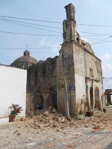
Unfortunately, the earthquake took its toll on these ancient buildings. What made them special is also what made them weak. When the earthquake hit, the old adobe bricks tumbled down like a stack of children’s building blocks. The town that was known for its chapels, churches and pre-hispanic structures will take time and money to rebuild. Some are a complete loss and many of the buildings will never be what they once were.
Yet, the Mexican people have quickly gotten on with their lives and tourism has returned. On weekends especially, people pour in from Mexico City and other parts of the country, hiring guides or moto-taxis and shown the attractions. So, it seems that perhaps with the chapels closed it drove the need for a new attraction and may by the reason they decided to open the pyramid of Tlatoani to the public.
Pyramid of Tlatoani opened March 21, 2018
There are few things that intrigue me as much as the mystery of ancient ruins that other people don’t know about. I’ve never had a desire to study archaeology, but I do feel a little like Hiram Bingham, the explorer who discovered Machu Picchu, when I can go to a place that has been lost, hidden or locked away. It excites and unlocks the little kid in me, my inner “Indiana Jones”. Perhaps you can related, perhaps we all have a little of that explorer inside.
So you can understand that I felt very privileged to be able to visit the Pyramid of Tlatoani with the archaeologist, himself, in January 2017, shortly after moving to the area. At that time it was still locked up and he had the key. He took me and a friend to the top of the mountain, showing us the areas that had been cleared, and telling us about its history. Since then I’ve been wanting to go again, to bring my friends and show them this special place.
When I learned that they were opening it to the public on March 21, 2018 I planned to return and and show another friend this hidden gem. I figured it was big news in town, so I asked around. Tlayacapan has a tourist kiosk in the plaza and I started there. I spoke with an older gentleman who told me about the local mountains and showed me a book of pictures, telling me how the mountains here were sacred because they all had a profile of a God or Goddess (Quetzalcoatl, Tonantzin, etc). He told their names and said he could guide me to any I wanted. But when I asked about the pyramid he had little to say. His information was sketchy and didn’t match up with what I already knew.
Then I tried inside the museum. They have a tourist desk as well. The man there was younger and I thought I was in luck. But he just directed me to ask at the tourist booth, where I had just been. I’ve learned that this is often what passes for information in Mexico. Few people really know what’s going on and usually I just have to gather what I can and explore and find the answers for myself.
With little to go on, I decided to explore and find out what I could. From what I could gather, it was only open on weekends from 10:00 am to 5:00 pm. I knew the way and I didn’t really want a guide, I figured we could find it on our own. I wanted the opportunity to walk at our pace and take time to explore the entire mountain. The problem was the gate to the pyramid is situated in the cliff, requiring a good climb before getting that far and we wouldn’t know until we got to there if it was even open. It was a chance we’d have to take.
Access to the pyramid is from an area of Tlayacapan known as El Plan (the plan). This is one of the prettier areas of town, with a few pools that were created to help with irrigation and water for the animals. The road passes by the Templo de Nuestra Señora del Transito, becoming a dirt road after the last houses, and hugging the mountain as it curves around to the base of the archeological site. The road is fairly level here and has been improved for the opening of the site. It may be possible to take a taxi or drive your car to this point, but we choose to walk (the distance from the church to the site is 1.4 kilometers, almost a mile).
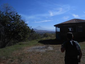
View of Popocatépetl from base of pyramid.
The entrance to the site has a kiosk and two round buildings. The buildings were constructed a few years ago and are currently used for storage. The kiosk was still under construction. This is probably where they will collect entrance fees in the future, but we found it empty. We could see that they are setting up posts for a gate as well.
With no one at the site entrance, we kept walking, realizing that we truly wouldn’t know if we could get into the pyramid until we got to the other gate, much further up. From here the town of Tlayacapan below came into view. The town sits in a bowl-like valley. We could see the center of town, the churches and temples, the fields of corn and cactus, and the surrounding mountains.
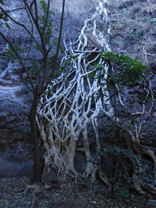
We soon passed by some rocks in the cliff that had cave paintings I’d been shown on my previous visit, but they are difficult to access so we didn’t try to find them. Here the amate trees grow along the cliff face. These trees have an elaborate root system that grows over the rock, stretching to find a footing in the soil below. The bark of the amate tree is used to make a parchment-like paper that is still used today in the local paintings. It is one of my favorite trees.
The higher we climbed the more we saw. To the left we could see the small mountain town of San Jose Los Laureles, where the road passes on it’s way up to Mexico City. On a clear day, you can see across the valley to the smoking volcano, Popocapetl, but unfortunately there was too much haze for us to make it out. To the right are more mountains, blocking the view of Oaxtepec and Cuautla, the bigger cities to the south.
After the entrance the trail starts to climb, with switchbacks taking you up to a saddle, rising to mountains on either side. I was told that if you follow the trail as it continues down the saddle, it takes you down to a stream, and perhaps even into the town of Ignacio Bastida below. But that will have to be an exploration for another time. We were going to the pyramid and I wasn’t going to let anything get in our way. So, we took the trail to the right and began the real climb.
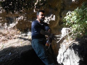
This part of the trail is a bit steeper. There are still some switchbacks, but there are also drop-offs and you have to be careful. After about ten to fifteen minutes more climbing the trail opens up at the base of the cliff and arrives at the gate. I was happy to find it open and attended by a local man named Oscar. I finally met someone who knew something about the place! Oscar told me that the hours I had been told are correct, though he is available on hire to take groups of people up at other times, even for sunrise or sunset. (This mountain sits right where the sun goes down, so it would be a beautiful view either time of day.)
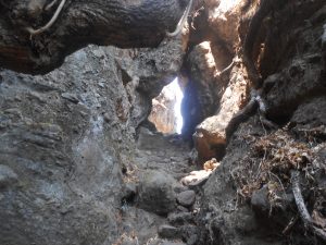
We paid him the entrance fee of $50 pesos each and went up through the metal gate. This is where it gets interesting (i.e. mysterious) for me. The trail climbs up a set of steps between the cliffs and I felt like I was traveling back in time. The pyramid or temple was built on top of the mountain, like a fortress or citadel, with far reaching views of the valleys below. This range of mountains splits the area with Yautepec, Cuernavaca and Tepoztlan on the west side with Tlayacapan and many smaller pueblos to the east. From this vantage point you can see towns and valleys on both sides of the mountain.
This gated entrance was one of the few that allowed access to the pyramid above. It’s how they kept it protected from invasion and from being taken by the Spanish Conquistadors. Not only was it hidden from being seen from below, but the access was easy to close and block off as well. (This was the easiest way up and the only one open, the others are still blocked.)
Ducking our head to maneuver between the overhanging rocks, we climbed the steps and came out on a small, level shelf with even better views! It was like a private window to the world below. The trail continued to climb, through more stairways, past narrow drops, going almost straight up at times, to level out as we arrived at the beginning of the stone terraces.
From here the terraces are built into the mountain top. They had been used for agriculture and also for dwellings. What they call a pyramid here is actually more like terraces, row upon row, that rise up to the formal temple area at the top. It isn’t what we’re used to calling a pyramid. In fact, I’ve heard visitors and tourists make sarcastic comments like “they call that a pyramid?” I find it hard to listen to the rude and judgmental people (these are the foreigners, not the locals). Reflecting on it, I’ve realized the stepped pyramids, which are the style in Mexico, are almost a way of replicating the form of these mountain terraces and I’ve come to appreciate and love them for what they are.
I have also learned that the Mexican people revere their pyramids, temples and sacred places. They will climb a pyramid in a reverent way, moving like a serpent as they ascend. Quetzalcoatl, the ‘plumed serpent’ represents illumination or enlightenment and they see the serpent as a sacred symbol. Climbing up the narrow steps they wind their way from left to right. This is a tradition honored at pyramids throughout the country.
At this particular site the steps from one level to the next one up were on alternating sides of the terrace so that this back and forth movement of the serpent’s body was part of the layout of the site and climbing in this way was embedded right into its form.
Finally at the top, we arrived at the temple. The stone walls were covered in the lime plaster that was used in ancient Mexico. The best of their construction was always at the highest level. The walls here were solid and strong, with views in every direction.
Since the site still has no formal signs or information, I will share a little more of what the archaeologist told us on my first trip. He explained that Tlayacapan had been originally settled by the Olmec people. Olmec pottery has been found here. I find this very interesting, since the Olmec were the earliest settlers of Mexico, but were more of a coastal civilization from the gulf areas of Veracruz and Tabasco. It was later settled by Xochimilcos, from the southern end of the Mexico City valley. He told us that a high percentage of the town’s population are descendants of the original inhabitants. The town and the settlements used to be much closer to the mountains, but when the Spanish came they set up the town further out in the valley (perhaps due to superstition and fear of the mountain areas).
We took our time, feeling into the energy of this sacred temple. When we started back down from the pyramid we met a large family on their way up. They asked where we were from and when I told them I lived in Tlayacapan we exchanged information. They were also from Tlayacapan and one of their daughters was named Ixchel, the same as me. We decided to get together (when I return from a trip to the US) to practice language conversation with each other. We had only passed one other small group that day. They were coming down while we were on our way up. I felt lucky to be here in the early stages, realizing that it may not stay that way for long. (On the other side of this mountain, the pyramid of Tepozteco in Tepoztlan has lines of people from top to bottom every weekend and keeps busy even throughout the week.)
Finding your way …
Tlatoani Pyramid
Sitio Arqueológico Cerro el Tlatoani is located 2.3 KM or 1.4 miles from the town center.
Climb the pyramid: Approx. 1 mile climb
Difficulty: Moderate
From the center of town you can ask around and see if a moto-taxi or regular taxi will take you to the site, or at least to the end of the paved road. (Or, if you prefer to walk from the town center, it will add about a mile to your walk.)
Visit Tlayacapan
Distance from Mexico City: 1.5-2 hours
Bus Lines: You can take either ADO and Flecha Roja from Mexico City (Taxqueña station) to Oaxtepec, 20 minutes south of Tlayacapan. Flecha Roja also has a stop in Tlayacapan, but is slower and goes through Xochimilco.
Combi or Taxi: From the Oaxtepec bus terminal you can find combi’s or collectivos or hire a taxi to go to Tlayacapan. The combi’s are a bright blue color and will say Tlayacapan. They pick you up on the main street, in front of the station. You can take any Tlayacapan combi (blue) to get into town and have them drop you off in the centro or at the main intersection of town.
There are plenty of hotels, Airbnb’s and other options for lodging.
Side Trips
San Jose Los Laureles is a small, mountain town just 4 miles away. You can easily get there by combi from the main road that comes into Tlayacapan. Visit San Jose.

